

Worldbuilding Guide: Nautical Pt. 3 - Navigation
Knowing where to go on the water.

Note: this subject matter requires some images and figures which increase the email size. For best experience, open this article in your browser or the Substack app.
Hello! I’m Ian Dunmore, and this is Dunmore Dispatch.
Normally I’m on here writing fantasy short stories, but I’m going to take a short break to write a worldbuilding and fiction guide for all things maritime!
If you’re new to this series, it’s advisable to start here. But honestly, it’s a free country. Start wherever you want.

In previous posts, we discussed onboard orientation, structural considerations, and sails / rigging. In this post, we’ll talk about navigation, or how sailors knew where they were and where to go.
To that end, I’ll be walking through various methods of navigation and orientation. We’ll be starting with some of the simplest methods and working up to the most complex tools requiring great infrastructure and effort: maps.
Like in our previous articles, I want you to pay attention to the human element alive within these tools. This isn’t just a survey of the how and what, it’s also a look into the heads of these sailors and pilots, the obstacles they faced, and the instincts they had to embody to tread the waves. And while you’re at it, you might be surprised to find just how many words we use for getting around trace their origins to these maritime techniques.
Here we go!
Navigation
This is an absolutely enormous subject that saw drastic evolution over time, but I want to forge ahead with these notes even if they’re not perfectly organized, which they’re self-admittedly not.
Premodern Navigation
Let’s take the case of early sailors, as in those without all the fancy technology afforded to Horatio Hornblower. This could apply equally to a viking longship as it could to Odysseus’ crew. Our craft is in some body of water and has to know where to go. What does the crew have at their disposal?
Landmarks
Look at landmarks such as the shoreline. Easy peasy.
Of course, one has to be familiar with the shoreline and said shoreline must be visible, but note that this method was not only for telling where you were, but what was going on beneath you, such as the presence of shoals and reefs, yet another set of facts the early navigator simply had to commit to rote memory.
If that’s prohibitive or the local geography too hazardous to trust one’s own judgment, then it’s time to find a local pilot, which was its own affair and actually encompasses traditions stretching all the way to the present. I’m saving piloting for further down, so put a pin in that.
Sounding and Lead Lines
If the crew can’t see but they’re close enough to shore, they could use their lead line to approximate their location.
Straightforward function: a heavy weight, usually a lead bell called a plummet or lead, gets tossed overboard attached to a line. The line is payed out (given rope, allowing the plummet to sink) until the line can be pulled taut, and markers along the line’s length indicate how deep it is. Do this twice, and you’ll have two data points in regard to depth. It can can at least get a sense of whether you’re approaching a high point (hopefully not a reef or shoal), moving away from it, or running parallel. Hand-held lead lines have been used since biblical times, and this whole affair of depth measurement is called depth sounding.
The operator of the lead line is called the leadsman. If the ship is moving he throws it from the prow out as far as he can in front of the ship so that hopefully by the time the ship reaches it then it will have hit bottom and therefore yield an accurate lead — the line of course has to be vertical or else you’ve got some quick trigonometry to do.
The line itself is (depending on region and era) measured in fathoms, units of six feet. Fathoms could be marked along the lead line with knots or ribbons of different color, but typically each mark was distinct so the leadsman could memorize them rather than having to count each time. The marked fathoms would have been announced by the leadsman with a shout of “Mark” followed by the number of fathoms, while the unmarked fathoms (those that get estimated) were preceded by “Deep” followed by the fathom count. This distinction between mark and deep might be compared to the way researchers use significant digits in their measurement as a way of indicating precision or confidence.
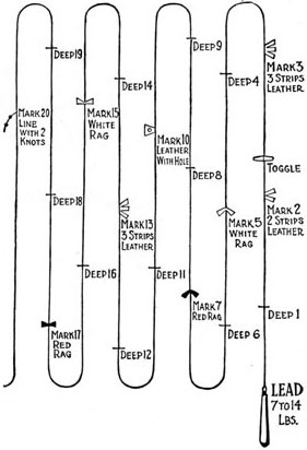
If units of less than a fathom were announced, it was only halves or quarters, but usually this was only necessary for riverine or harbor traffic where you could expect to find such shallow waters. If you need to know the water’s depth to a higher resolution than eighteen inches (a quarter fathom), then you’ve got bigger problems.
You might hear the leadsmen shout out expressions like the following:
“By the mark – five!” (five fathoms; 30’, dead- or close to dead-on the lead line’s five-fathom mark)
“By the deep – four!” (four fathoms; 24’, measured approx. halfway between marks three and five)
“By the mark – less a quarter seven!” (6.75 fathoms; 40.5’, approx. ¼ fathom shy of the seven fathom mark)
Fun fact: the great American author Samuel Clemmons worked as a licensed Mississippi steamboat pilot, where it was common to hear a leadsman sound out a depth of twelve feet, or two fathoms, read off from the marks on the lead line as “By the mark – twain!”1
An additional use of the plummet itself was that it was often bell-shaped with a concave recess in its underside. This recess could be stuffed with a bit of wax or tallow so that when the drowning plummet struck the water’s bed then some of the bed’s contents could be caught in the wax and drawn back up. Knowing whether the stuff beneath you was sand or silt or clay, or what color any of those were, might tell our crew a lot about where they are.
This method of sounding wasn’t just for the water outside the ship. If our crew is in a particularly bad storm and under threat of foundering (filling up with water and sinking), they might need to measure internal water levels. You would certainly not want to hear the captain furtively command a trustworthy officer to “sound the bilges, fore and aft.”2
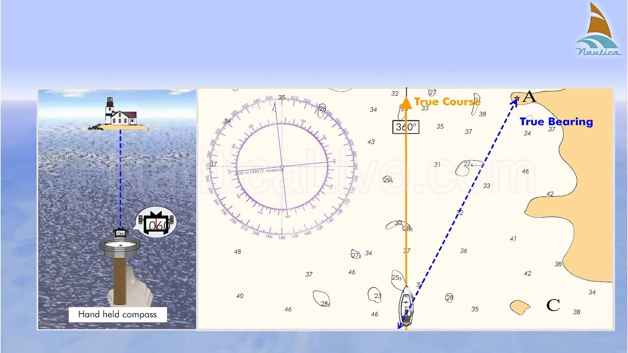
Compasses
Ah, the compass! A handsome, blonde sailor standing at the wheel of a frigate flicks open a pocket compass like a flip phone, smiles at the results, and shouts something sailor-y like, “Avast, ye mateys!” as he turns his vessel directly into a headwind. Surely a compass is a sailor’s fastest friend! What else could a mariner possibly need?!
If that’s your mental picture, prepare yourself for some disenchantment.
Compasses have been used for at least nine-hundred years and are an enormous topic. I’m going to gloss over a lot of details, but compasses are so ubiquitous in media that I think they’re important to get a sense of…
Magnetic Compasses
Magnetic compasses are the ones you’d naturally think of, and the same ones you can buy at any outdoors outlet. They consist of a light and magnetized bit of something (called the needle) fixed to an axis, framed by a compass rose.
They needn’t be arcane devices; actually, they’re shockingly simple to make. So much so that I’m going to describe how to make one right now with readily available materials:
Start with a magnetic needle. This could be a lodestone — a magnetized bit of metal (usually iron from a stream (usually magnetite, for whoever cares)) — but you could get creative. So long as it’s sufficiently magnetized, it’ll do.
Place your selected needle on some sort of light, buoyant platform like a thin bit of wood or even a leaf.
Balance that on a liquid. Water will do, but something thicker like quicksilver might work better (assuming you’re unconcerned about mercury exposure). You can get fancy by removing the liquid, but start here for simplicity.
Now watch as your cute little needle on its cute little boat naturally orients north toward Santa’s workshop. Wunderbar!
The earliest compasses in China used just this formula: a spoon-shaped iron needle suspended on water on a bronze basin. Every magnetic compass employs this simple and miraculous method of pointing north.
… And every magnetic compass is just a wee bit wrong.
Magnetic North, True North, and Declination
Recall: magnetic compasses work by orienting toward the north. This works because the needle aligns with Earth’s magnetic field, which you can imagine as a giant invisible force wrapped around the globe. It’s maintained by a number of factors, from ocean currents to magma flows in the Earth’s outer core,3 and it also helps to deflect some of the sun’s most harmful ionizing rays. If you’ve ever watched an aurora without fear of having your bone marrow shredded by radiation as the Earth turns into an uninhabitable husk, then you can thank magnetism.
These fields all trace across the Earth from south to north, terminating all at the same point near the north pole.4 That means, excluding anomalies (we’ll talk about those), you could follow a compass needle from any point on Earth and it would take you to magnetic north.
Notice I didn’t say, “north.” I said, “magnetic north.” They’re not quite the same.
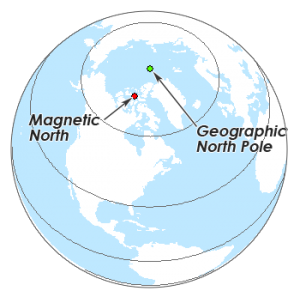
That maddening difference between magnetic (the red dot in the figure above) and true north (the green dot), is accounted for in declination. Magnetic declination is the difference in angle between magnetic north and true north for any given point.
Wait, it gets worse, because magnetic north also drifts over time, a phenomenon called polar wandering! And if your ship itself is metal, then I’ve got even more bad news…5
How they handled it
The response to this depended on the era and the need.
Few peoples noticed magnetic declination prior to The Age of Exploration because they generally never sailed or traveled far enough for it to matter. But that also means they didn’t need to worry about it. Even if your compass isn’t pointing exactly north, you can still follow a heading between Point A and Point B provided those locales aren’t too far apart — north-south travel was generally more forgiving than east-west in terms of declination.
And, plenty of masterful sailors didn’t use compasses at all. Leif Erikson sure didn’t when he sailed from Europe to North America a thousand years ago.
In 1088, Shen Kuo of China noted that a needle point rubbed with a magnetic stone pointed almost south, but not quite.6 European sailors started to notice during The Age of Exploration. Explorers noted the phenomenon, and some like Columbus even attempted to chart the degree of deflection as they went.
This brings up two points:
It’s absolutely mind-blowing that sailors at such an early time would notice and endeavor to record this!
However, the fact that they noticed a disparity between where north was and where it should be — enough so that they took to recording it — suggests that they already kind of knew where they were.
After that, charts started coming with declination recorded (more on that later) and would usually measure magnetic compass readings against a mechanical one.
Mechanical Compasses (Gyrocompasses)
These are much simpler, and don’t use magnetism at all. Here’s what you do:
Get a gyroscope — a device that generally maintains its orientation and angular momentum due to inertia.
Use a magnetic compass and declination chart to calibrate it to true north.
Depending on the quality, it will remain pointed exactly that way for a long time while your ship moves around!
… but not forever. Sooner or later you’ll need to recalibrate it, probably after a really bad storm or some preset period of time. Wait until you’ve made port or are in calm waters and reset it.
All of that said, we’ve moved way beyond the capabilities of our early sailors. Gyrocompasses are decidedly modern instruments — especially when the ships themselves were metal and would thereby introduce their own magnetic deflections.
You can follow a compass heading to a nearby location, but you still need to understand what you’re going to encounter along the way. How ‘bout I cover up all the windows of your car, give you a compass, and let you go driving? I don’t care if your destination is 100 yards away, I’ll bet you wouldn’t take me up on that.
You need more than a compass.
The Firmament
Let’s say there’s no shoreline. Say our ship is in the open sea. Well, you still have the sky. During the day our crew can see the sun, and knowing the approximate time they might ascertain at least their general latitude (how far north or south one is relative to the equator). At night, they of course have constellations, but this would also require a sense of timing because the firmament is rotating above them on Polaris’ axis as the hours progress (Polaris is the North Star, and remains generally in the same place in the sky throughout the night).
That said, nocturnal chronology means they can see where an eastern or western constellation is sitting relative to the horizon to get a sense of time — e.g. if we’re around Iberia’s latitude and Perseus’ foot is touching the western horizon in early autumn, it’s just after midnight — but that’s also totally dependent on the time of year, yet another encyclopedia of information our early navigator would simply have to memorize. That memorization frequently occurred through folklore, similar to mnemonics.
Early sailors might have a shadow stick or cross staff to help with this. Cross staves can be used both during the day and night, but for it to be accurate they’ll need to have at least a sense of what time it is.
And once again we see the pattern: many of these tools heavily depended on not only carefully reading angles and distances, but also units of time.
Approximate latitude could be surmised with either one of these tools or via the naked eye by observing the altitude of Polaris. A sailor would have a pretty good way of calculating using their fingers at arm’s length, for example. This is still used today in teaching constellations, actually: if you find The Lazy-W (Cassiopeia), then Polaris is about 2.5 star-lengths away to the right.
Longitude was its own beast. That problem wouldn’t get a solution until much, much later, and the fact that it remained unsolvable for so long explains why Brazil’s official language is Portuguese, not Spanish.
I’ll come back to that once we reach the section on maps.
Astrolabes
Astrolabes weren’t originally for sailing, but they were sometimes used for such. You can think of them as astonomical multitools.
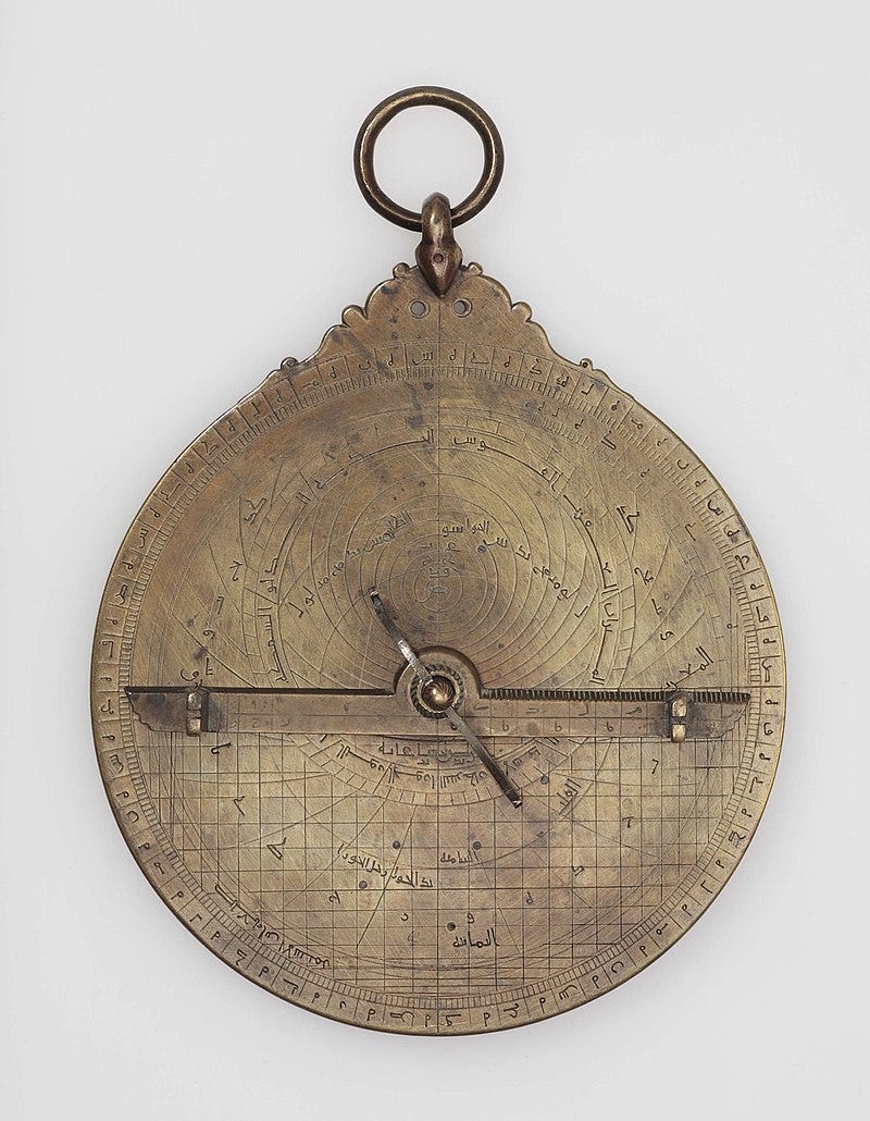
They could be used as star charts, inclinometers (tool for measuring angles of slopes), astronomical calculators, altimeters, and more. Way back in the 10th century astronomer Abd al-Rahman al-Sufi wrote a book with almost four-hundred chapters on an astrolabe’s applications.
Astrolabes themselves are beautiful things, composed of ornate discs with interlocking pieces across their face, often engraved with the stars and constellations.
There’s much that could be said here, but like many of these tools in order to accurately use one to determine position you also needed to know time of year and sometimes time of day. If it’s a nocturnal astrolabe it will be geared toward Polaris which mostly doesn’t move, although some were built for the moon as well. If it’s solar, it will have to be used at noon, and the farther off 12:00pm you go the less accurate it will be. If it’s lunar, it was usually calibrated to a midnight moon.
And as I said before, these weren’t originally for nautical navigation, nor even land nav. Although they could be used for both, you can probably guess that sailors’ needs demanded tools more adapted to the waves, which is why later iterations were made sturdier and simpler for nautical usage.
Sunstones
Let’s take away the sky now, and any landscape. Weather is overcast or stormy and our crew is in open water. What have we got?
There are primary sources from just after (not during, but after) the viking era that speak of sunstones, transparent stones that polarize light and, when looked through, can reveal the location of the sun through clouds. Like many viking-era things, sunstones have developed a legendary mystique, but they’re not especially mysterious. They’re made of calcite.7 They work.
While sunstones were certainly real and their solar application understood, there’s little direct evidence that these were used for nautical navigation (but in all fairness, there’s little direct evidence for much at all regarding vikings, or at least a lot less than most people assume). Actually, their direct mention for this purpose comes from the following medieval hagiography called Guðmundar saga góða:
The weather was thick and snowy as Sigurður had predicted. Then the king summoned Sigurður and Dagur (Rauðúlfur's sons) to him. The king made people look out and they could nowhere see a clear sky. Then he asked Sigurður to tell where the sun was at that time. He gave a clear assertion. Then the king made them fetch the solar stone and held it up and saw where light radiated from the stone and thus directly verified Sigurður's prediction.
If we can trust this source, then it tells us three things:
Sunstones worked.
Vikings knew about them and how to use them.
…But they didn’t need them.
Note this third point, because it’s kind of the thesis of this section.
Chip Logs and Dead Reckoning
There’s also the chip log, which you could use to ascertain dead reckoning.
The way this worked was relatively simple: you had a board (the log) on the end of a long line which acts as a drogue, a general term for a device designed to create drag (the words drag and drogue are cognates, meaning etymological cousins). The line attached to the drogue is fitted with knots at regular intervals as markings, similar to a lead line. You drop the log into the water and pay out the line until those knots are flying off the spool at regular intervals. From there, since you know the distance between each knot, you can count how many knots sink over the gunwale at a given time interval, and from there calculate your ship’s speed.
Look! Another immediate need for accurately measuring time! Drink!
Also, notice that what this is really measuring is the velocity vector of your craft with respect to the water. In other words, if your craft is going x knots and the current is going the opposite direction at y knots, then after calculating the vector your formula is speed = x - y. This distinction between absolute and relative vectors is usually referred to as real (absolute) and apparent (relative), and also applies to vectors such as wind.
Of course, the formula I shared above assumes our craft and the current are in the same line of action – if the angle isn’t 0 or 180, then you’ve got some trigonometry to do… or not do unless your angle is 30, 45, or 60 because you have neither calculator nor ledger of trig ratios. Basically, if you’re in any sort of current, then obtaining real speed (as opposed to apparent) won’t be any kind of precise.
To be fair, most of the ocean isn’t current, so this could tell us our speed, and if our navigator combines this knowledge with the knowledge of some past position, heading, and elapsed time, he could ascertain their current location by way of what’s called dead reckoning, a metric still utilized well after fancy tools like chronometers and sextants came into play. Dead reckoning is basically, “We began at Gibraltar and our heading was bound for Jamaica and we’ve been averaging about five knots for three weeks, so by dead reckoning we should be nearing three-quarters of the way across the Atlantic.”
But now we’re getting back to that rough-edges navigation, the “blacked out car windows with compass and stopwatch” navigation. It’s also arguable that chip logs were an invention of the Age of Exploration, so while they could have been used in premodern times there’s no evidence of their use before the 1400s.
Equally probable is that, like sunstones, they weren’t needed.
And even in the 15th century where chip logs were first used for dead reckoning, the ship’s maneuvers would also need to be recorded in a ledger (technical term being a logbook; “Ship’s log, date…”) and combined with a compass heading. Imagine trying to work out dead reckoning after three full days of tacking through open sea.
The fact that dead reckoning was the best tool sailors had for most of human history actually had major consequences on world events. Latitude could be worked out to the nearest thousandth of a degree using an astrolabe, but in the late 15th century longitude was up to the navigator’s intuition. Remember how I said disparities in longitude led to modern language differences? After Columbus’ voyage, he and his Spanish patrons appealed to the Pope in 1493 for permission to own all the land west of the 38th Meridian, which they got in the Bull Inter Caetera. The Portuguese, while preoccupied with Cathay and the Spice Islands, were vaguely aware that there was land out there, and wanted to make sure they weren’t losing a slice of the western pie. In 1494 they demanded the Pope move that line further west, and the Pope (whose position at that time was already losing authority as Christendom’s umpire) announced at the Treaty of Tordesillas that the new delineator lay at 46 degrees, 37 minutes west of Greenwich. Thus the Portuguese got a significant enough segment of modern Brazil to claim it.
Pilots
Now we come not to a tool, but a matter of personnel. We know of the term for pilot being the one who’s steering the ship, but pilots were also a localized phenomenon as one entered ports, much like how on today’s GPS driving directions one needs far more detailed instructions at the very beginning and end of a trip. It’s not always possible or cost-effective to bring along a member with local navigation knowledge.
You don’t buy a trail map before you’ve arrived at the National Park, you get one at the visitor’s center. This is where we get pilots.
The Ancient Pilot
As I alluded to above, if our crew is new to these waters, a guide is an expedient solution. Sure, the navigator might have some or all of the tools mentioned above like lead lines and such, but the qualifiers on each should tell you how inefficient this could be. Far easier to outsource the whole affair. The roots of the word “pilot” are a bit debated, but one possibility is it comes from the Dutch words pijl lood which means “pole lead,” a reference to sounding techniques, which you can probably guess pilots did a lot of.
Captains during The Age of Exploration went to great lengths to obtain pilots with local knowledge. They achieved this using highly competitive employment methods called “kidnapping” and “enslavement.” Vasco da Gama, after rounding the Cape of Good Hope, ran through a revolving door of Indian Ocean pilots trying to find one that was knowledgeable enough in the local waters. It paid off for him, if not for all the poor fellows he abducted. Columbus did it, too. So did Magellan. And others.
Let’s use a tamer scenario, though. If the waterway is well-trafficked but sees ships from distant places with regularity, local piloting can give rise to its own small industry.
The Sandy Hook Pilots
By way of example, take the Sandy Hook Pilots (native to Sandy Hook, New Jersey, not Connecticut). Yes, these pilots belong in the modern era, but the same principles would apply in ancient times. The Sandy Hook Pilots association was established in 1694 – just seventy years after Dutch colonists founded a trading post that would become New York City – and they served the ports of New York and New Jersey, the Hudson, and Long Island Sound by navigating ships through The Narrows, the tidal strait between the bodies of Staten Island and Brooklyn.
The Sandy Hook Pilots kept a clinker whaleboat at Sandy Hook, waiting for a ship to come by. When they spied one, they would row out and hail it, and hopefully the pilot would be hired and brought aboard to guide the ship further in. Similar provisions were made at other ports such as Boston and Charleston, where pilots would rendezvous in the open water outside the bay to guide ships on their last mile(s).
As New York City commerce accelerated (especially after the completion of the Erie Canal) pilotage became fiercely competitive, and pilots would literally race their schooners out to be the first to intercept a ship and have their services hired.
The Sandy Hook Pilots are still in operation today, doing the same thing they’ve been doing for over two-hundred years. It’s one of the oldest continuous pilot associations in the world with one of the most rigorous certification processes in the country.
Point being, if our crew is at its final stretch and the port is well maintained, they might have a pilot sail up to their craft and hail them for hire, much like the dinghies you see today that motor up to cruise ships to sell t-shirts or bananas or whatever. And often, our crew would be wise to rent their services.
Charts
Charts were often essential parts of a captain’s repertoire. These weren’t just maps of the ocean, though, they required far higher degrees of fidelity as the ship drew closer to its destination, much like how modern GPS navigation can generally guide you to stay on the interstate until you’ve taken a few exits and are now on minor arterials and residential roads.
A General Note on Maps
In the present era we tend to take this stuff for granted, but cartography is a tedious and expensive endeavor, usually requiring some sizeable upfront commission. In the American Revolutionary War, Washington paid a pretty penny to have a faithful, colored pencil map made of Boston whilst besieging the city. More presently, American combat operatives in Afghanistan in the 2010s were using the same maps the Soviets had been using in the 1980s. It’s little wonder that the ability to rapidly render satellite images is an absolute game-changer for not just navigators, but warfare, economics, and environmental sciences.
But let’s back up for a moment. As abstruse as it sounds, it should be stated that as a rule maps are simplifications. We might not think of them this way, but this is why modern tools like ArcGIS (the gold standard of electronic mapping software) use layers to suit the viewer’s needs. You might not care about buildings or landmarks, you might only care about elevation, ergo you use a contour map layer. Or maybe you only care about paths, in which case a road map will suffice. Or maybe you’re looking for waterways, in which case you’ll opt for something else.
A map can never show you everything. The Map-Territory Relation principle developed by Alfred Korzybski says that a map that shows everything in a given area would necessarily need to be just as large as said area in order to accommodate the gross volume of information.8
It’s like the movie Synecdoche, New York, but for maps. I don’t know who among you will understand that reference, but for the ones who do, you’re welcome.
Cartographers recognized the Map-Territory Relation as early as the 5th century when trying to tackle a seemingly simple problem: measuring the length of a coastline. Each surveyor who attacked the problem came back with wildly different answers. As it turns out, it’s mathematically justifiable to say that every coastline is infinitely long.
I say all this because I think it’s important to appreciate. Old maps with their strange perspectives and Here be Dragons get a lot of flak today. It’s easy to forget that our standard top-down view where every house is a nice little box and trees are these green circles is actually a very unnatural vantage that no human would have ever been naturally afforded prior to airplanes or balloons. Rather than cleaving to the elusive standard of “accuracy,” it’s important when looking at old charts to ask ourselves what it’s trying to convey. In a word, purpose.
For our ancient crew, regional charts and rutters (sailor’s guidebooks; in classical antiquity it would have been called a periplus) could be purchased locally — again, think buying a trail map at the National Park entrance. Like many of the other navigation tools were often the private property of the captain rather than being counted among the ship’s effects. If a captain left the services of a given ship, he’d be taking his maps with him, a testament to charts’ values.
Nautical cartography is too big of a subject for me to neatly inscribe. Instead of an exhaustive survey, here are just a few of the interesting things charts might track:
Topography
This was often a product of detailed surveys, although said surveys might be a very long time inbetween. When new surveys were completed for Raritan, New York, and Newark Bays in 1848 (a region, as I mentioned, that was quite heavy on nautical traffic), it was to replace surveys conducted by the British almost a century prior and drawn decades before the Declaration of Independence was signed. Such surveys were a tedious business, requiring detailed soundings, triangulation, astronomical fixes, and the like. In fact, most of the topography charts available for US seaports in that era came through a single contractor out of Boston named Edmund Blunt. Such publications came in guidebooks and were referred to as a sailing direction or coast pilot.
Navigational aids
These could include lighthouses, light vessels, and buoys. It’s a big subject so I’ll save it for another post, but it bears noting here.
Shoreline
Usually this was fairly cursory, but there are some places like the southeast coast of Ireland where charts would come on these long, horizontal scrolls and have illustrations of the cliffs from a ship’s point-of-view, which could then be used to reference a typical aerial map for location. I can’t find any sources for this, but I’m certain I remember seeing them when I visited Ireland’s County Cork.9 If anyone has pictures or sources to share on this then please reach out because I’d love to see them.
Magnetic Variation
We’re back to compasses! Columbus started jotting down declination on his travels (although complete declination charts would come much later than that), but as we discussed before, declination describes magnetic variation due to magnetic north not being the same as true north. Here I want to talk about another more regionally-bound hurdle of localized magnetic anomalies, faced by Captain Cook in the South Pacific or early polar explorers.
Some maps called isoclinic charts which go back at least to the 19th century would show areas where compasses get skewed by localized magnetic fluctuations. This is in contrast to generalized fluctuations (i.e. declination), which you would need an isogonic chart to track — look at all these charts you have! A captain could literally spend a small fortune on them!
As far as what causes magnetic anomalies, igneous rock was almost always to blame, particularly ferromagnetic — in other words, magnetized iron deposits belched by volcanoes. Think Puget Sound or the Faroe Islands.
Note that iron is the fourth most abundant element on the Earth’s crust by mass. It’s almost everywhere. Not any iron is going to do this. To induce this type of anomaly — and yes, anomaly is the technical term here — it needs to be magnetic.10
We’re kind of staring down a rabbit hole of geology and physics right now,11 but for our purposes it could be somewhat reductively said that lava flows can “shape” the iron they leave behind into these great big magnets that can play havoc with your poor, magnetic compass.
The good news is that this shouldn’t affect you too much. Dipole magnetic flux tapers off at an inverse cubic rate!
Here’s what that means in basic English:
Measure your compass deflection at some distance from the magnetic source. Now move twice as far away from the source as you were before and measure again. At twice the distance, the magnetic flux — the amount the compass needle will skew from magnetic North — will be not one-half, but one-eighth what it was before!
That is a really, really steep rate of tapering off. For compass deflection to matter, you would have to be very close indeed, and your anomalous source very strong. If you’re fabricating a setting where this occurs, recent volcanic activity will serve you well.
When All Else Fails
What I’ve spelled out above is that there was much for early sailors to learn, remember, and possess, but likely the greatest tool a sailor had was intuition born of experience. Tools get finicky, the heavens get occluded, compasses drift and wobble, horizons dance and vanish, and the waters reach their wet fingers into every craft. This isn’t to say that the arsenal of tools I mentioned weren’t at all necessary or utilized, just that they weren’t relied upon in the same way we might rely on Google Maps. In our medieval account, Sigurður pointed without hesitation at the exact location of the sun and was immediately confirmed by the sunstone. The goal of being a successful sailor was to learn the ways of the ocean as easily as breathing. It’s not only the capricious waves themselves that lend the oceans their unknowable mystique, it’s also the ineffable discipline required to master them.

And that’s all for now! I hope you’ve enjoyed this series and learned something! I’m sure I’ll come back to it, but for now I’m going to get back to some fiction.
Speaking of fiction, here’s a story I wrote that implements some of the ideas discussed in this and previous articles in this series:
The Lass and the Firth's Pilot

In the cold hours of first light she waited. Wrapped in an ill-fitting coat, sitting beneath a lamp fixed to a whitewashed tavern wall. She stared out ahead at the Firth of Merei cloaked in morning’s blue fog.
"Twain” of course being an archaicism for “two.”
Spoiler: it means the captain thinks you’re taking on water, and that the water at one end of the ship might be higher than the other. If the captain is ordering this, you should probably find yourself a life jacket, stat.
Not lava. Lava is when it’s above the Earth’s crust, magma is when it’s below. This distinction matters to geologists for reasons!… I don’t know what they are, but I assume they’re good.
This is imprecise of me. The magnetic fields don’t terminate at this point, they go underground and shoot out the other end of the planet, completing loops around the Earth. I left that out because it seemed abstruse for our purposes.
When the deflection is due to factors like ships, it’s called magnetic deviation. Magnetic declination specifically refers to that angular difference between magnetic and true north.
Thank you to Charles Midi for pointing this out to me!
At least, the famous one, the Iceland spar, was confirmed to be calcite. Maybe another was made of something else like dragon scales, I don’t know.
As a further embellishment, The Map-Territory Efficiency principle developed by Ian Dunmore says that that hypothetical map would be useless. And also very silly.
One source I found claimed they’re among the 18th and 19th century British Admiralty Sailing Directions, but I was unable to confirm this.
Unsurprisingly, the best ferrous mineral for the job is called magnetite, which should hopefully be pretty easy to remember. Many other ferrous minerals didn’t have the crystalline chemical structure to induce magnetism, such as those bound up with silicates (hornblende, biotite) and therefore would effect compass needles negligibly. This explains why the Japanese archipelago was (a) birthed from volcanoes; but (b) is lacking in ferromagnetic anomalies and overall quite poor in accessible, high-grade iron sources. This absence of easily available iron has influenced all sorts of things throughout their history, from building design to swordsmithing techniques to imperial strategies in World War II.
I’ve thought about doing one of these worldbuilding guides specifically on geology and its effect on life, human settlements, agriculture, and warfare — if anyone’s interested in that, feel free to shout out!
Here's a little something that you probably didn't know. Compasses were set into binnacle boxes that were built off of the deck. The compasses were so sensitive that any iron (nails, copper sheathing, bolts, the rudder, hinges for doors) could mess up the compass reading. The best way to get a good reading was to build it about waist high. In addition, navigators had sextants, which were devices used to measure the distance between the sun or moon and the horizon. Earlier navigators used a T-Stick which was a staff with a Y carved into the top. It was used the same way, to get a good look at the distance between two objects, such as the deck and the top of the mast.
People should read this and study it. It would make their sailing descriptions much better.
This is all absolutely fascinating and written in such an engaging manner. I got a bit confused in the compass section: did you mean "because true north also drifts over time" or is it magnetic north which does that?